Multifunctional coopERative marine roBOTs for Intervention DomainS
Project start:
01/01/2015
Project end:
31/12/2017
The methodology designed uses up to three heterogeneous vehicles cooperating in different configurations at each phase of the mission. A first stage is implemented with an Autonomous Underwater Vehicle (AUV) endowed with acoustic and optical sensors and a Surface vehicle (ASC) whose mission is the localization and supervision of the AUV and link it to the remote base. This configuration is used to elaborate, first, an acoustic map on which a second survey of the AUV is planned. Later, the AUV uses the optical sensors and moves closer to specific regions to record detailed information of potential targets. The data from these surveys, georeferenced by the ASC, permit obtaining an accurate 3D reconstruction of the area under study to plan the intervention stage. Next, an operator, using an HMI that includes a target recognition system, identifies the target and plans the manipulation stage. Finally, a Hybrid-ROV with a multifunctional system formed by a manipulator and a hoover carries out the supervised intervention task. During this stage, an AUV equipped with cameras stays close and supports the HROV operation providing images from an external viewpoint. This complementary information guarantees a robust and realiable manipulation, which is essential in archaeological missions. A good communication link between vehicles is important in all the stages of the mission, but critical during the last one. Hence, we will develop new wireless underwater communication systems, allowing the vehicles to exchange commands and images.
The application of the project has been focused in underwater archeology, although the same technologies could be applied in other scenarios. Two distinctive missions will be required to realistically face the problem.The first one (Fig. 1), cooperative survey, will comprise an autonomous survey of the seabed by means of an AUV assisted by a surface vehicle that provides absolute localisation and communication. The second mission (Fig. 2), cooperative intervention, will comprise a semi-autonomous intervention by means of an HROV assisted by an AUV providing an external view of the intervention.
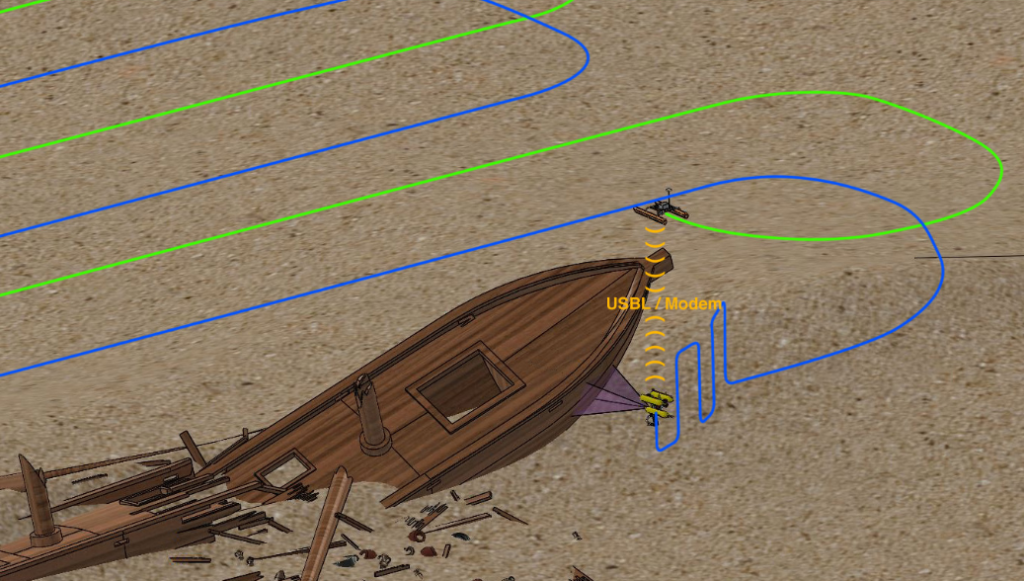
Fig. 1: Cooperative Survey
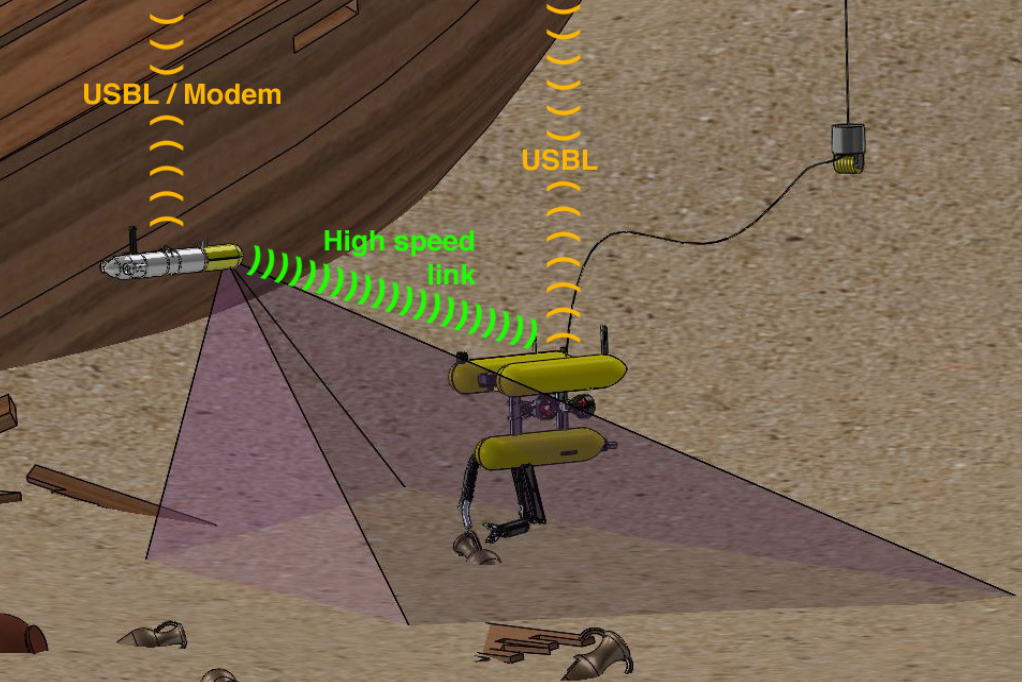
Fig. 2: Cooperative Intervention
Consortium
MERBOTS is Coordinated by Pedro J Sanz (IP1) and Raúl Marín (IP2) from UJI and has been organized into 3 subprojects:
- [MERMANIP, UJI] In charge of the multisensory based autonomous manipulation, the multimodal user interface, and the RF communication system for enabling compressed image transmissions between the robots and the human operator. Coordinated by MERBOTS Coordinators.
- [ARCHROV, UdG] Responsible for the cooperative mobile robotics part, including communication and localization of the mobile robots, sonar-based survey, and path planning, also the construction of a new ASC and the final mechatronics, hardware/software integration will be under their responsibility. Coordinated by Pedro Ridao (IP1) and Marc Carreras (IP2).
- [SUPERION, UIB] Responsible of processing the multimodal sensor data collected during the survey stage to build 3D models of the area of intervention and the target, as well as for searching the target prior to the intervention and tracking the target during the intervention. Coordinated by Gabriel Oliver (IP1) and Alberto Ortiz (IP2).
| Sub-Project name | ARCHROV DPI2014-57746-C3-3-R | MERMANIP DPI2014-57746-C3-1-R | SUPERION DPI2014-57746-C3-2-R |
| Project coordinated by |  |  |  |
| IP1 | Pere Ridao (Partner UdG) | Pedro J. Sanz (Partner UJI, Coordinator) | Gabriel Oliver (Partner UIB) |
 |  |  | |
| IP2 | Marc Carreras | Raúl Marín | Alberto Ortiz |
Acknowledgments
![]()
This research was partly supported by Spanish Ministry of Research and Innovation DPI2014-57746-C3.